PedoScale
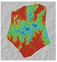
In pedology, soilscapes are characterised by a typical spatial and taxonomic relation between the soils, as well as by the relation between the soils and other landform and landscape characteristics. These landscape characteristics as driving forces for soil formation show local, regional and supra-regional components. It is therefore important to gather and incorporate information about the soil forming factors not only from a specific sampling point, but also from its larger spatial surroundings for reasonable descriptions of the complex soil-landscape relations.Therefore, multi- or hyper-scale approaches are required, which however, are rarely reported in literature. Moreover, most studies are lacking any interpretations and concepts for the description of soil formation, although these are most crucial for describing and understanding the complex environmental processes and interactions of landscapes and soils.
The aim of this project is to develop a new hyper-scale mapping approach as well as a new theoretical concept for its pedologic interpretation. Under the overarching goal of a new spatially contextualized soil formation theory the objective of the project is to achieve more holistic descriptions of soil and environmental formation but also the optimization of spatial prediction models for estimating soil properties functions and threats. This is urgently needed in order to meet the increasing global demand for accurate and high-resolution soil information to estimate and handle the impacts of global climate change, population growth, food security, and bio energy.
The framework, which will be developed, applied, tested and validated for several landscapes around the world in this project, focuses on determining the influence of local, regional and supra-regional landscape surface shape on soil formation in terms of hyper-scale digital terrain analysis and tries to reveal the interactions of relief with other environmental covariates on different spatial scales. The objectives are (i) to develop a new hyper-scale terrain analysis method, (ii) to apply, develop and/or adapt specific data analysis and data mining approaches to derive the information required for pedological interpretations and as an integrative part (iii) to develop a new theoretical framework for soil formation analysis. This will provide a) information on the specific influence of local to supra-regional parts of environmental covariates on soil formation, b) approaches to visualize the geomorphic systems interacting with other covariates and jointly influence soil formation, c) approaches to derive information on the interactions between different geomorphic features and scales, as well as d) information on the complex interactions between geomorphic and other environmental covariates at different scales to derive better knowledge about the spatial distribution as well as the genesis of one of our most important environmental resources - soil.
 |  |  |  |
| Overview | |
|---|---|
| Project | PedoScale - Hyper-scale digital soil mapping and soil formation analysis |
| Start/End | 2012-2015 |
| Funding | DFG |
| Keywords | Digital Soil Mapping, Digital Relief Analysis, Data Mining, Knowledge Discovery |
| Contact | Thorsten Behrens |