Module "Data Analysis and Modeling Methods in Geoscience and Environmental Science"
Principles of the Module
The module "Data Analysis and Modeling Methods in Geoscience and Environmental Science" is obligatory for students in the MSc Geowissenschaften/Geociences and open to students of the MSc Applied and Environmental Geoscience and the MSc Geoökologie/Geoecology.
The module consists of three units that can freely be selected over the entire course of the MSc studies. For some units, prerequisites are defined (e.g., one of the two programing languages offered). There are more units selectable than needed to fill the module. Students can fill a second module "Data Analysis and Modeling Methods in Geoscience and Environmental Science 2" as elective. The individual units are offered either over 4 weeks within the lecturing period of the semester, or as one-week block course. The module is graded by the average grade of the three units.
NOTE: This page gives an overview over all units available. Not all of the units listed might be offered in the respective summer/winter semester. Check the detailed description and the availability of units on ALMA in the respective semester and register as early as possible so lecturers can estimate the demand.
Units available in the Winter Semester

Introduction Scientific Programming (Matlab)
This course provides an introduction into scientific computing, data analysis and programming using the software package MATLAB, specifically with respect to:
- Reading, writing, manipulating and plotting data
- Matrix algebra, solving linear equation systems and linear regression
- Programming loops and conditional statements and writing functions
- Solving simple differential equations and parameter inference.
The content taught in this unit (or in the introduction into Python) will be required for many of the units in this module. Please check the requirements before registering, as no other introduction into scientific programming will be provided.
Note that the course is intended for MATLAB beginners.
Taught by: Christiane Zarfl
Introduction Scientific Programming (Python)
The course provides an introduction into scientific computing, data analysis and programming using PYTHON, specifically with respect to:
- Reading, writing, manipulating and visualizing data
- Solving simple mathematical concepts such as linear regression
- Programming loops, conditional statements, and functions
- Solving simple differential equations and parameter inference
The content taught in this unit (or in the introduction into Matlab) will be required for many of the units in this module. Please check the requirements before registering, as no other introduction into scientific programming will be provided.
Taught by: Reinhard Drews
Introduction to R
This course is an introduction to the R language and environment and its potential applications for geology and palaeontology. The focus is on learning the basics to enable students to further deepen their learning by themselves. No prior knowledge is required. The course is project-based and the students will build their own scripts and present the resulting analyses using only tools in R.
Contents:
- Introduction to the R language, basic mathematical operations, loading data, loops and how to write functions
- Tidying data and statistical tests in R: comparisons and correlations, regression, statistical models
- Graphics in R
- R Markdown and how to improve communication and replicability
Taught by: Gabriel Ferreira
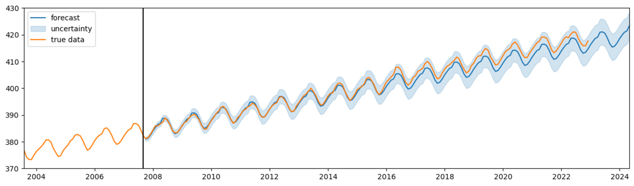
Introduction to Time Series Analysis
In this course we look at what distinguishes time series from other types of data, at basic ways to model them with probability theory and numerical computations, at how to analyze their characteristics and how to create simple forecasts.
The course relies on active participation in the tutorials, where the learned techniques are applied to real and artificial data using Python. The final task is a group-based mini project analyzing a time series of your choice.
Taught by: Kira Rehfeld, Jakob Kruse
Machine Learning 2
In this course we’re going to go into depth of state-of-the art machine learning, especially deep learning methods (Transfomers, Diffusion Models, etc.) and take a look at their potential for applications in the geosciences. The lectures are accompanied by programming tutorials and the course is evaluated through a coding project.
Some prior coding experience and knowledge of machine learning (e.g. through the Machine Learning 1 block course) is necessary.
Taught by: Nicole Ludwig
Units available in the Summer Semester
Advanced Time-Series Analysis
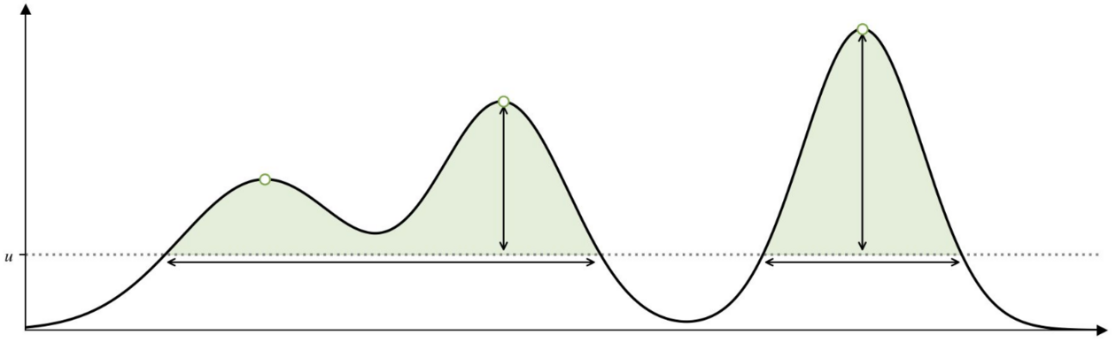
This course deepens the understanding of time series behavior gained in TSA1, although prior attendance of TSA1 is not required. The focus is on correlations and causality, power spectra and the Fourier transform, as well as the statistics of rare extreme events.
The course relies on active participation in the tutorials, where the learned techniques are applied to real and artificial data using Python. The final task is a group-based mini project analyzing a time series of your choice.
Taught by: Kira Rehfeld, Jakob Kruse
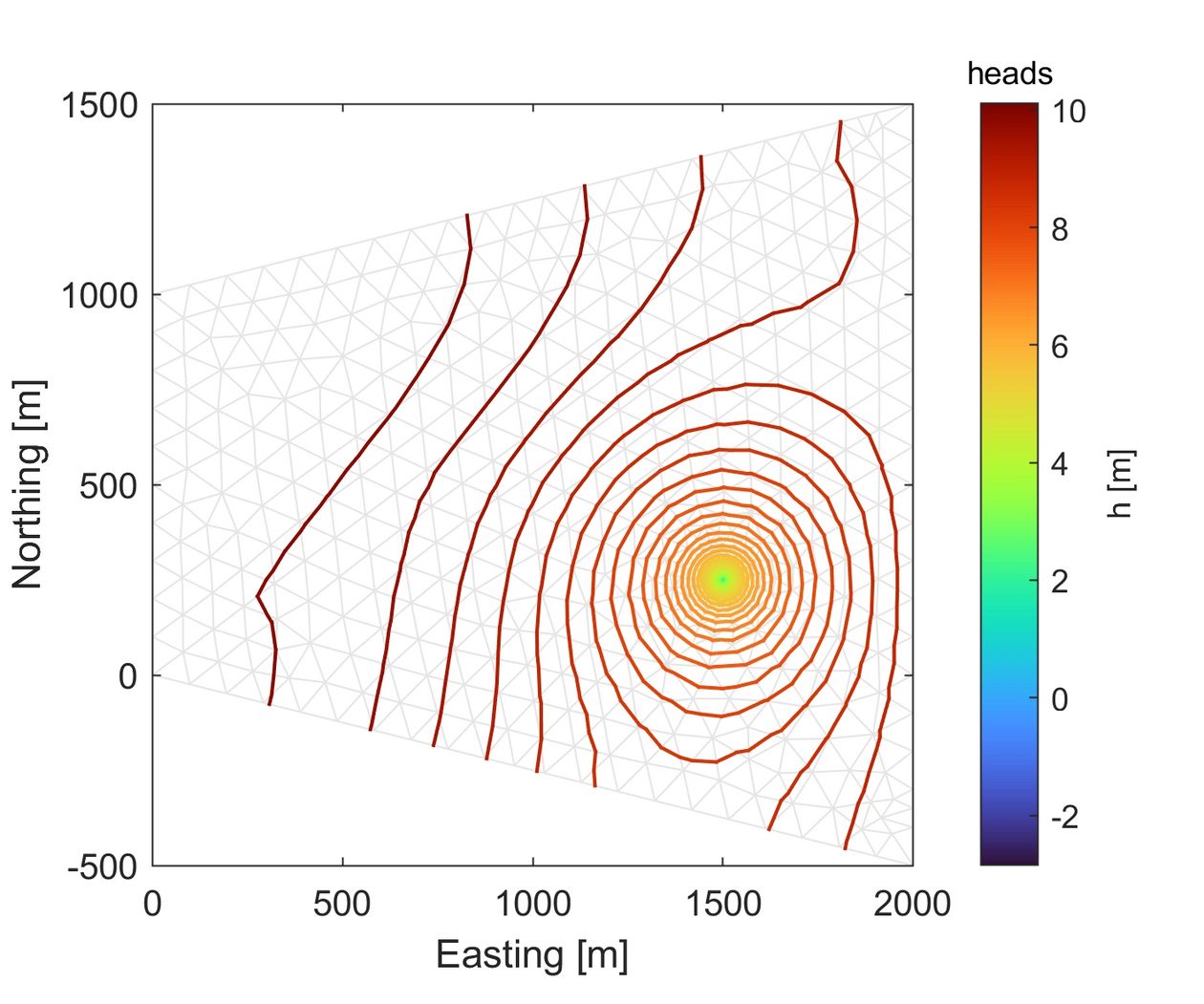
Finite Element Method
This course gives an introduction into Finite Elements, a discretization technique for partial differential equations that allows unstructured grids (i.e. grids that are not organized in rows, columns, and layers). As simple applications, groundwater flow and linear transport of solutes and heat are considered. The students build a matlab code from scratch. Grading is based on the written code with a report.
Content
- Reminder of Finite Volumes (working with indices, building the system of equations, etc.)
- Method of weighted residuals
- Isoparametric concept
- Use of grid generators
- Standard Galerkin code for groundwater flow (diffusion, heat conduction, direct-current geoelectrics)
- Petrov-Galerkin methods for advection-domnated solute transport
Prerequistes
- Matlab programing
- Knowledge of underlying conservation laws for flow and transport
- Decent understanding of vector calculus (gradient, divergence, divergence theorem, Green's theorem) and linear algebra (matrix multiplications)
- Mathematical fearlessness and endurance
Taught by: Olaf Cirpka
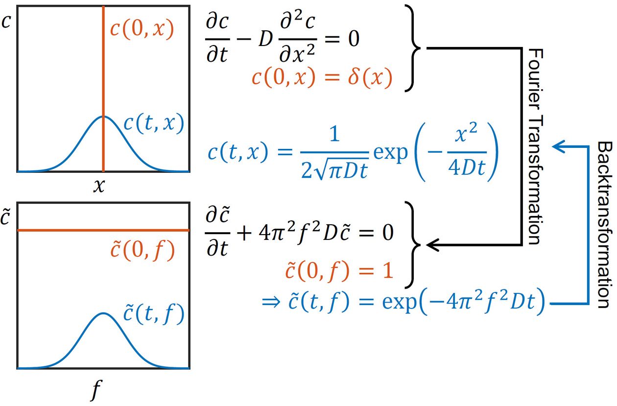
Fourier- and Laplace-Transform Techniques
Did you ever wonder why the solution to the diffusion problem for a point source is the Gaussian distribution? Do you want to know how to solve problems involving kinetic inter-phase mass transfer without relying on cumbersome numerical methods? Then you need "tricks" not taught in regular classes on flow and transport.
This course discusses the analytical solution of linear partial differential equations describing transport problems using Fourier- and Laplace-transformation techniques.
Taught by: Olaf Cirpka
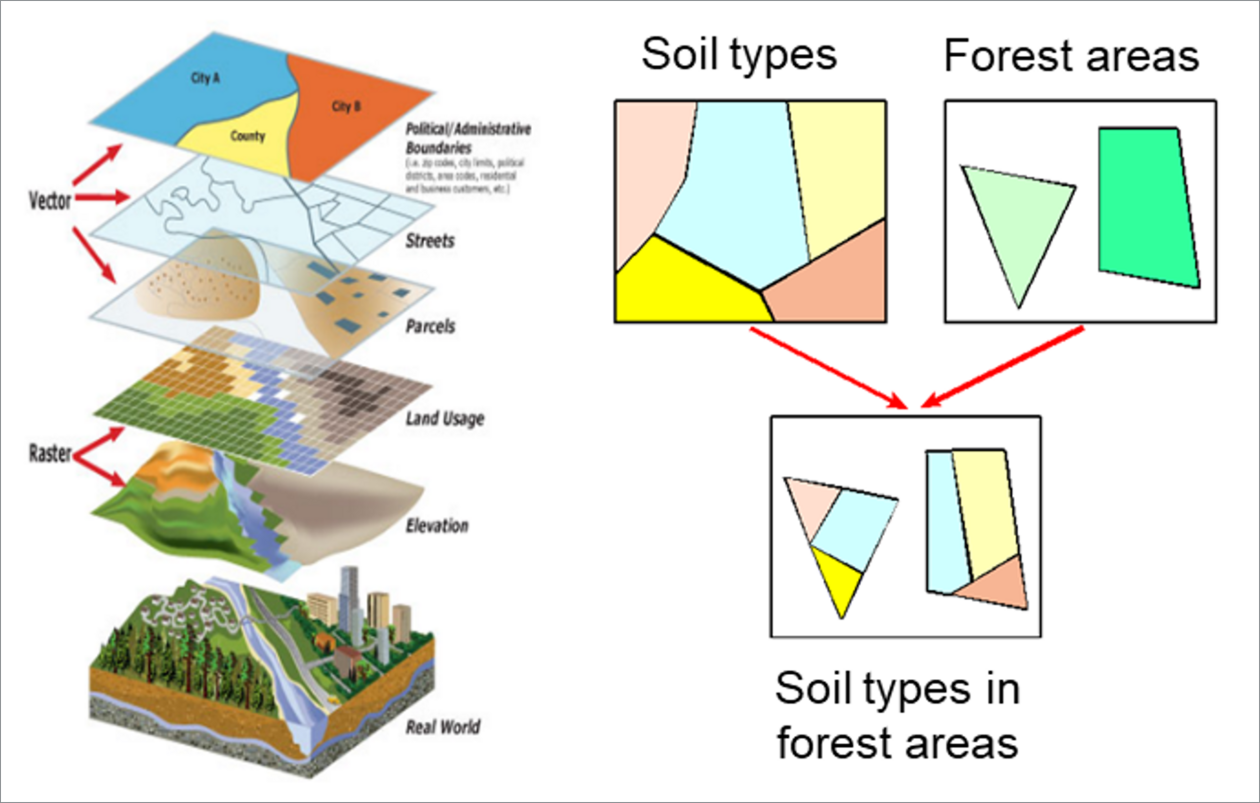
Geographical Information Systems
This course provides an introduction into spatial data analysis with GIS, specifically using the software ArcGIS. Contents will include:
- GIS: definitions, vector (vs. raster) data, projections
- Tools for spatial data analysis for vector data
- Data compilation, data pre-processing
- Data representation, map design
The course is a combination of lecture and hands-on exercises from georeferenced data acquisition to poster presentation. The final assignment includes the preparation and presentation of a poster.
Note that the course is intended for GIS beginners.
Taught by: Christiane Zarfl & Rebecca Peters
Machine Learning 1
In this course we’re going to learn about the basics of machine learning, starting with a few core mathematical principles, before learning about specific methods (PCA, Gaussian Processes, Variational Autoencoders, etc.) and how to build a machine learning model with a special emphasis on applications from the geosciences. The lectures are accompanied by programming tutorials and the course is evaluated through a small homework assignment.
Some prior coding experience and knowledge of time series analysis will be very helpful but is not required. We’ll be programming in Python.
Taught by: Nicole Ludwig
Principles of Model Calibration
This module is recommended for Master's students who are interested in mathematical modeling and Matlab applications. You will learn the basic principles and methods of mathematical model calibration. The course is a well-designed mixture of lectures, in-class as well and homework exercises. We will have examples and discussions about questions like: Why do we use models? How to calibrate them properly? How do we know whether the calibrated model works? What can we do to improve (the reliability of) the model? What kind of methods are available? How can they be implemented (in Matlab)?
In the best case, you end up with a good understanding of model calibration and a healthy skepticism about calibrated models. Some experience in using Matlab will definitely help to enjoy the course. The participation in some modelling class (such as Environmental Modelling 1) may ease the understanding.
Taught by: Michael Finkel
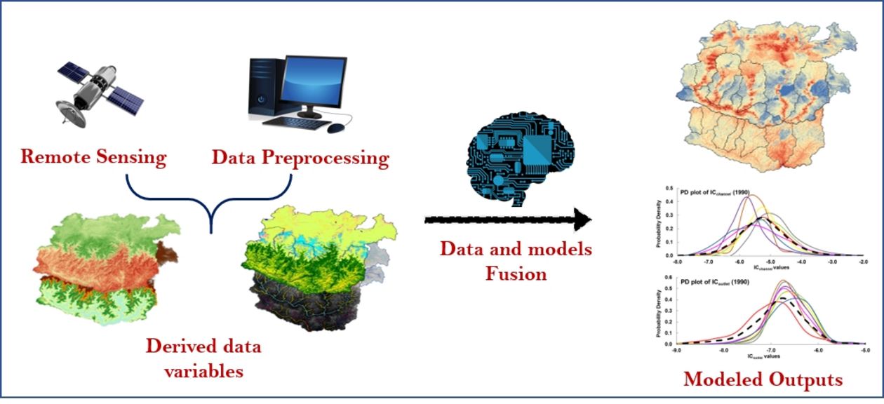
Remote Sensing of River Systems
Remote sensing and image analysis are invaluable tools for resource management. Studying this unit will extend your capacity to apply the advanced aspects of remote sensing and image processing.
Focusing on case studies with special emphasis on component of a river system with various remote sensing data, sophisticated models, tools, and techniques will provide a unique opportunity to advance our understanding and quantification of a multitude of processes and their interactions within the Earth system at spatiotemporal scale.
Taught by: Kanchan Mishra