19.12.2022
Machine learning reveals differences in long-range weather connectivity patterns for different kinds of El Niño events
In their latest article, published in Geophysical Research Letters, Felix Strnad and Jakob Schlör from the Machine Learning in Climate Science Cluster Research Group use complex network curvature to show that different El Niño events in the Pacific correspond to different global connectivity patterns.
El Niño events, characterized by anomalous sea surface temperatures (SSTs) in the tropical Pacific, come in two flavors: Eastern Pacific (EP) and Central Pacific (CP) types, depending on the longitudinal location of the strongest SST anomalies. The remote impacts of these events, also known as teleconnections, differ based on whether an EP or CP event is taking place.
Although there are many studies investigating teleconnections of EP and CP events for individual target regions, a global analysis is still lacking. This is where the team from the Machine Learning in Climate Science group stepped in. Their study sheds new light on the El Niño phenomenon and how its correlations around the world are dependent on its "type" i.e. whether its center of action is in the Eastern Pacific or the Central Pacific
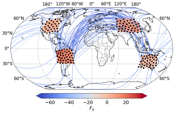
What started out as a semester project with former Master student Christian Fröhlich soon evolved into a full scale study of long-range teleconnections of El Niño events. Using the notion of ‘curvature’ of complex network edges, the team showed that the edges of ‘climate networks’ are positively curved when they are regional and negatively curved when they are long-range. The climate networks themselves are constructed based on statistically robust correlations estimated from global surface air temperature data. Climate network curvature provided an objective way to study the differences in spatial organization of teleconnections of different kinds of El Niño events at a global scale.
“Network curvature, especially for climate networks, is an intuitive yet informative tool to visualize the structure of a network which allows conclusions to the spatial organization of long-range links. Although we use it to study the El Niño phenomenon, one can use this technique in principle to study any correlation-based similarity measure of climatic variables such as rainfall or pressure”, says Strnad, while talking about the power of climate network curvature as a visual analytics tool.
Interestingly, the Central Pacific does not show many teleconnections, even during CP El Niño events which we attribute to the varying location of warm water anomalies in the Central Pacific. The Eastern Pacific changes more consistently allowing to identify remote impacts of both El Niños types. “While remote impacts of EP and CP El Nino events have been known for decades, these teleconnections have been studied individually. Our curvature-based analysis gives a global picture of teleconnections and reveals that EP events have a strong impact on the Tropics while CP events also show impacts on the mid-latitudes. Global climate models only partially capture the diversity of El Nino events and their teleconnections. Climate network curvature could be used to evaluate how well these models capture the remote impacts we see in observations,” acknowledges Schlör.
Original publication:
Strnad, F. M., Schlör, J., Fröhlich, C., & Goswami, B. (2022). Teleconnection patterns of different El Niño types revealed by climate network curvature. Geophysical Research Letters, 49, e2022GL098571. https://doi.org/10.1029/2022GL098571

