In this dissertation coupled atmospheric, land surface and hydrological models are going to be used on Large-Eddy-Simulation (LES) scales of 20 to 100 m to simulate the water budget in small catchments under different realistic weather conditions. The weather and research model (WRF) (Skamarock et al., 2008) is going to be used for the atmospheric part, NOAH-MP (Niu et al., 2011) for modelling the land surface and WRF-HYDRO (Gochis et al., 2013) for the hydrological component.
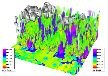
The improvement of quantitative precipitation forecasting (QPF) is one of the main focuses of research in atmospheric modelling. Especially convective precipitation events are highly dependent on local effects like orography, soil moisture content and evapotranspiration. Therefore, understanding and modelling the water fluxes in catchments is one of the basic tasks for improving the ability of numerical weather prediction (NWP) models. The lowest part of the troposphere, called the planetary boundary layer is influenced by turbulent exchange processes. Traditional NWP models cannot resolve turbulent processes due to their coarse resolution. Thus, the governing processes in the planetary boundary layer are parameterized, which leads to uncertainties in the exchange fluxes between the atmosphere and the land surface. To overcome these shortcomings of traditional NWP, these models have to be employed on a grid increments of around 100 m and finer. At those scales, the energetically important part of the atmospheric turbulence spectrum can be resolved directly, thus it is spoken of large eddy simulations (LES). Additionally benefits of a high resolution are an improved representation of the land use, the topography and the soil texture in the model, as changes in the properties at the land surface happen usually on a scale smaller than 1 km.
WRF allows simulations in LES scales down to 10 m under realistic conditions. Because WRF is able to perform dynamical downscaling, nesting the LES domain in larger domains is possible. High resolution data assimilation at 2.5 km with a 3DVAR rapid update cycle is used to produce a mesoscale reanalysis data set for Europe. From there, nesting of smaller sized domains with finer resolutions down to the LES scale is performed. Therefore, it will be possible to test the LES domain under different realistic weather conditions and to simulate the exchange between the atmosphere and the surface in those situations. Up to date most of the LES studies are set up with periodic boundary conditions and are operated under idealized conditions at the land surface. Therefore, utilizing LES with a model traditionally applied for NWP as a testing framework will lead to new insights regarding boundary layer processes and the parameterizations of those processes, as most of the mathematical models like the similarity theories were developed for fair weather conditions.
Land surface models, as they are applied generally in NWP show a couple of severe simplifications in describing the hydrological budget at the land surface. For example, lateral transport of water on the land surface and in the ground are not represented. Lateral runoff processes can alter the moisture distribution significantly, they can have a decisive influence on the surface energy balance and thus on the organization of the flow in the lower troposphere. Furthermore, as the amount of humidity in the atmosphere is often a threshold value for the vertical stability of the tropospheric stratification, the distribution of soil moisture has a large impact on the evolution of convective systems like cumulus clouds or thunderstorms. Hence, the simulation of lateral water fluxes is an important part for the development of integrated earth system models and the improvement of precipitation forecast. In this study, the surface hydrology will be represented by an enhanced formulation of the hydrological budget at the land surface, allowing for lateral transport of water.