Dr. Andreas Braun
Address:
Universität Tübingen
Geographisches Institut
Rümelinstr. 19-23
D-72070 Tübingen
Sprechzeiten: Dienstag 12:30 - 14:00
Westbau 1. OG / Raum W407
Tel.: +49-(0)7071-29-78940
E-Mail: an.braun(at)uni-tuebingen.de
CV
01/2022 - today
University of Tübingen
Akademischer Rat (senior lecturer): Lectures and courses on physical geography and methods in geography Studienfachberatung M.Sc. Physiche Geographie
11/2013 - 12/2022
University of Tübingen
Researcher at the working group for geoinformatics and lecturer at the chair for Physical geography and GIS
06/2014 - 07/2019
Dissertation at Eberhard-Karls-Universität Tübingen
Title of PhD thesis: Radar satellite imagery for humanitarian response. Bridging the gap between technology and application. URL: http://hdl.handle.net/10900/91317
2015 - 2017
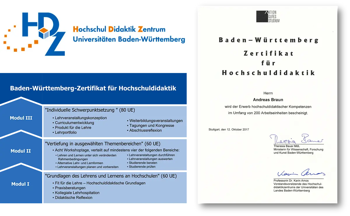
Studies of university didactics
Received Baden-Württemberg certificate at the HDZ: http://www.hdz-bawue.de/das-angebot-des-hdz/baden-wuerttemberg-zertifikat/
07/2013 - 10/2013
Stadtmessungsamt Stuttgart, Fachbereich Geoinformatik
Land surveying office, department for geoinformatics
10/2010 - 06/2013
M.Sc. "Landscape System Science / Geography" at Eberhard-Karls-Universität Tübingen
"Landscape System Science" 
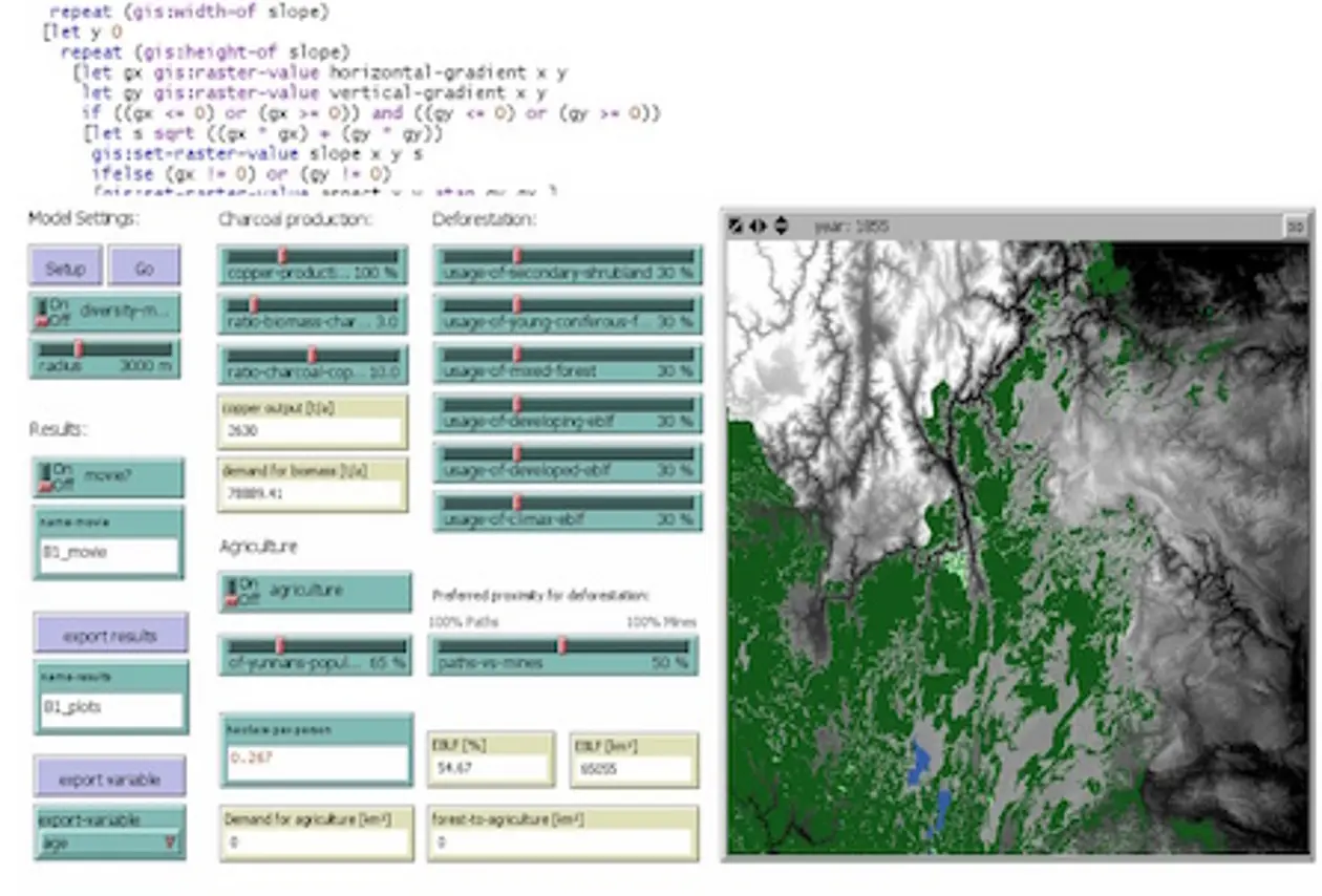
Master thesis: "Rekonstruktion und Modellierung von Landschaftsveränderungen mit Geosimulation" (Reconstruction and modeling of landscape change with geosimulation)
10/2007 - 09/2010
B.Sc. Geography at Eberhard-Karls-Universität Tübingen
Bachelor thesis: "Störung und Sukzession: Möglichkeiten agentenbasierter Systeme zur Modellierung empfindlicher Ökosysteme" (Disturbance and succession: Potential of agent-based systems for the modeling of vulnerable ecosystems)
Publications
Peer-reviewed articles
2022
-
Gella, G.; Wendt, L.; Lang, S; Tiede, D.; Gao, Y.; Braun, A. (2021): Mapping of Dwellings in IDP/Refugee Settlements from Very High-Resolution Satellite Imagery Using a Mask Region-Based Convolutional Neural Network. Remote Sensing 14(3), 689. doi.org/10.3390/rs14030689. PDF
-
Matabishi, J.G.; Braun, A.; Warth, G. (2022): Multiple endmember spectral mixture analysis of DESIS image to identify rooftops in Kigali. The International Archives of Photogrammetry, Remote Sensing and Spatial Information Sciences 46, 39-47. doi:10.5194/isprs-archives-XLVI-1-W1-2021-39-2022. PDF
2021
-
Braun, A. (2021): Retrieval of digital elevation models from Sentinel-1 radar data – open applications, techniques and limitations. Open Geosciences 13(1), 532-569. https://doi.org/10.1515/geo-2020-0246. PDF
-
Minh, T.N.; Sebesvari, Z.; Souvignet, M.; Bachofer, F.; Braun, A.; Garschagen, M.; Schinkel, U.; Liang, E.Y.; Linh, H.K.N.; Hochschild, V.; Assmann, A.; Hagenlocher, M. (2021): Understanding and assessing flood risk in Vietnam: Current status, persisting gaps and future directions. Journal of Flood Risk Management. doi:10.1111/jfr3.12689. PDF
-
Duffy, C.E.; Braun, A.; Hochschild, V. (2021): Surface subsidence in urbanized coastal areas: PSI methods based on Sentinel-1 for Ho Chi Minh City. Remote Sensing 12(24). doi:10.3390/rs12244130. PDF
2020
-
Braun, A.; Hoeser, T.; Delgado Blasco, J.M. (2020): Elevation change of Bhasan Char measured by persistent scatterer interferometry using Sentinel-1 data in a humanitarian context. European Journal of Remote Sensing 54(1), 109-126. doi:10.1080/22797254.2020.1789507. PDF
-
Warth, G.; Braun, A.; Assmann, O.; Fleckenstein, K.; Hochschild, V. (2020): Prediction of Socio-Economic Indicators for Urban Planning Using VHR Satellite Imagery and Spatial Analysis. Remote Sensing 12(11), 1730. doi:10.3390/rs12111730. PDF
-
Braun, A.; Warth, G.; Bachofer, F.; Bui, T.; Tran, H.; Hochschild, V. (2020): Changes in the building stock of Da Nang between 2015 and 2017. Data 5(2), 45. doi:10.3390/data5020042. PDF
-
Braun, A.; Hochschild, V.; Pham, G.T.; Nguyen, L.H.K; Bachofer, F. (2020): Linking land subsidence to soil types within Hue city in Central Vietnam. Journal of Vietnamese Environment 12(1), 1-6. doi:10.13141/jve.vol12.no1.pp1-6. PDF
-
Braun, A. (2020): Spaceborne radar imagery – An under-utilized source of information for humanitarian relief. Journal of Humanitarian Engineering 8(1).doi:10.36479/jhe.v8i1.164. PDF
2019
-
Lang, S.; Füreder, P; Riedler; Wendt, L.; Braun, A.; Tiede, D.; Schoepfer, E.; Zeil, P.; Spröhnle, K.; Kulessa, K.; Rogenhofer, E.; Bääuerl, M.; Öze, A; Schwendemann, G.; Hochschild, V. (2019): Earth observation tools and services to increase the effectiveness of humanitarian assistance. European Journal of Remote Sensing 53(2), 67-85. doi:10.1080/22797254.2019.1684208. PDF
-
Vetter-Gindele, J.; Braun, A.; Warth, G.; Bui, T.; Bachofer, F.; Eltrop, L. (2019): Assessment of household solid waste generation and composition by building type in Da Nang, Vietnam. Resources 8(4). doi:10.3390/resources8040171. PDF
-
Braun, A.; Fakhri, F.; Hochschild, V. (2019): Refugee Camp Monitoring and Environmental Change Assessment of Kutupalong, Bangladesh, Based on Radar Imagery of Sentinel-1 and ALOS-2. Remote Sensing 11(17), 2074. doi:10.3390/rs11172047. PDF
-
Bachofer, F.; Braun, A; Adamietz, F. Murray, S.; d’Angelo, P.; Kyazze, E.; Mumuhire, A.P.; Bower, J. (2019): Building Stock and Building Typology of Kigali, Rwanda. Data 4(3), 105. doi:10.3390/data4030105. PDF
- Warth, G.; Braun, A.; Bödinger, C.; Hochschild, V.; Bachofer, F. (2019): DSM-based identification of changes in highly dynamic urban agglomerations. European Journal of Remote Sensing 52(1), 322-334. doi:10.1080/22797254.2019.1604083. PDF
2018
- Braun, A.; Wagner, J.; Hochschild, V. (2018): Above-ground biomass estimates based on active and passive sensor imagery in low-biomass savanna ecosystems. Journal of Applied Remote Sensing 12(4). doi:10.1117/1.JRS.12.046027. PDF
- Braun, A. (2018): Assessment of building damage in Raqqa during the Syrian civil war using time-series of radar satellite imagery. Journal for Geographic Information Science 1/2018. 228-242. doi:10.1553/giscience2018_01_s228. PDF
2017 and before
- Braun, A.; Hochschild, V. (2017): Potential and limitations of radar remote sensing for humanitarian operations. Journal for Geographic Information Science 1/2017. 228-243. doi:10.1553/giscience2017_01_s228. PDF
- Braun, A.; Hochschild, V. (2017): A SAR-Based Index for Landscape Changes in African Savannas. Remote Sensing 9(4), 359; doi:10.3390/rs9040359. PDF.
- Braun, A.; Lang, S.; Hochschild, V. (2016): Impact of refugee camps on their environment. A case study using multi-temporal SAR data. Journal of Geography, Environment and Earth Science International 4(2), 1–17. doi:10.9734/JGEESI/2016/22392. PDF
- Braun, A.; Hochschild, V. (2015): Combining SAR and optical data for environmental assessments around refugee camps. Geospatial Minds For Society, 424–433. doi:10.1553/giscience2015s424. PDF
- Wendt, L.; Hilberg, S.; Robl, J.; Braun, A.; Lang, S.: Using remote sensing and GIS to support drinking water supply in refugee/IDP camps. Geospatial Minds For Society, 449–458. doi:10.1553/giscience2015s449. PDF
- Braun, A.; Rosner, H.J.; Hagensieker, R.; Dieball, S. (2015): Multi-method dynamical reconstruction of the ecological impact of copper mining on Chinese historical landscapes. Ecological Modelling 303, 42–54. doi:10.1016/j.ecolmodel.2015.02.013. URL
- Neckel, N.; Braun, A.; Kropácek, J.; Hochschild, V. (2013): Recent mass balance of Purogangri ice cap, central Tibetan Plateau, by means of differential X-band SAR interferometry. The Cryosphere 7, 1623–1633. doi:10.5194/tc-7-1623-2013. PDF
Book chapters, conference proceedings and others
- Hochschild, V.; Braun, A.; Sommer, C.; Warth, G.; Omran, A. (2020): Visualizing Landscapes by Geospatial Techniques. In: Edler D., Jenal C., Kühne O. (Eds): Modern Approaches to the Visualization of Landscapes. RaumFragen: Stadt – Region – Landschaft. Springer VS, Wiesbaden, 48-78. doi:10.1007/978-3-658-30956-5_4.
- Rogenhofer, E.; de Laborderie, S.; Vyncke, J.; Braun, A.; Schwendemann, G. (2020): EO data supporting Médecins Sans Frontières's medical interventions. In: Ferretti, S. (Ed.): Space Capacity Building in the XXI century. Springer International Publishing. ISBN 978-3-030-21938-3.
- Braun, A.; Warth, G.; Bachofer, F.; Hochschild, V. (2019): Identification of roof materials in high-resolution multispectral images for urban planning and monitoring. Joint Urban Remote Sensing Event (JURSE). doi:10.1109/JURSE.2019.8809026.
- Braun, A.; Hagensieker, R.; Hochschild, V. (2016): Filling of Cloud-Induced Gaps for Land Use and Land Cover Classifications Around Refugee Camps. Proceedings of Living Planet Symposium (SP740) 09.–13.05.2016, Prague. PDF
- Schillaci, C.; Braun, A.; Kropácek, J. (2015): Terrain Analysis and Landform Recognition. In: Clarke, L.E & Nield, J.M. (Eds.) Geomorphological Techniques (Online Edition). Chapter 2.4.2. British Society for Geomorphology; London, UK. ISSN: 2047-0371. doi:10.13140/RG.2.1.3895.2802. PDF
- Braun, A.; Hochschild, V. (2015): Combined use of SAR and optical data for environmental assessments around refugee camps in semiarid landscapes. The International Archives of the Photogrammetry, Remote Sensing and Spatial Information Sciences, Volume XL-7/W3, 777–782. doi:10.5194/isprsarchives-XL-7-W3-777-2015. PDF
- Unterweger, P.; Braun, A. (2015): Die Initiative Bunte Wiese. Machen wir's bunt! Natur & Garten 1/2015, 6-11. ISSN: 2199-7012
- Claus, C.; Braun, A.; Scholz, D.; Tielbörger, K. (2014): GLOWA JR Atlas: Results of the GLOWA Jordan River Project. Online-Publikation. URL
- Unterweger, P.; Braun, A. Koltzenburg, M.; Betz, O.: Die Initiative Bunte Wiese - Für mehr Artenvielfalt auf öffentlichem Grün. In: Korn, H.; Bockmühl, K.; Schliep, R. (Eds.): Biodiversität und Klimawandel. Vernetzung der Akteure in Deutschland. Bundesamt für Naturschutz, Bonn / Bad Godesberg, 53–54, ISBN 978-3-89624-092-7. PDF
- Braun, A.; Rosner, H.J. (2013): Agent-based modeling of landscape dynamics due to copper mining industry in the north-earstern Yunnan Province, Southeast China, during Qing Dynasty (1644-1911). In: Vogel, H.U.; Cao, J.; Shan, K. (2012): Proceedings of the fifth international Workshop of the DFG Research Group Monies, Markets and Finance in China and East Asia 1600 - 1900 (in press).
- Unterweger, P.; Ade, J.; Braun, A.; Koltzenburg, M.; Kricke, C.; Schnee, L.; Wastian, L.; Betz, O.: Langfristige Etablierung extensiver Grünflächenpflege in Stadtgebieten. Die Initiative „Bunte Wiese“ der Stadt Tübingen. In: Veit, U.; Korn, H. (Eds.): Treffpunkt Biologische Vielfalt. Aktuelle Forschung im Rahmen des Übereinkommens über die biologische Vielfalt vorgestellt auf einer wissen-schaftlichen Expertentagung an der Internationalen Naturschutzakademie Insel Vilm vom 20. - 24. August 2012. PDF
- Braun, A.; Rosner, H.J. (2011): Modellierung ökologischer Sukzession mit Multiagentensystemen. In: Helbich, M.; Dreierling, H.; Zipf, A. (Eds.): Heidelberger Geographische Bausteine 19, 95–101. ISBN: 978-3-88570-819-3.
- Braun, A.; Rosner, H.J. (2011): Disturbance and succession. Potential of agent-based systems for modeling vulnerable ecosystems. Application to land degradation pro-cesses. In: Car, A.; Griesebner, G.; Strobl, J. (Eds.): Geospatial Crossroads at GI_Forum 2011. Proceedings of the Geoinformatics Forum Salzburg, 05. - 08.06. University Of Salzburg, Wichmann Verlag, Berlin, 12–21. ISBN: 978-3-87907-496-9. PDF
Selected presentations
- Braun, A. (2021): Relationship of urban heat with building density and green spaces - a remote sensing-based study across Vietnam's metropolitan areas. The 11th International Forum on Green Technology and Management: Green Pathways towards a sustainable future (IFGTM 2021), 26. November 2021, Can Tho, Vietnam.
- Braun, A.; Bachofer, F. (2021): Soil Types and Construction Activity as Drivers of Surface Subsidence in Coastal Urban Areas. The Case of Hue in Central Vietnam. ESA FRINGE 2021, 11th International Workshop on "Advances in the Science and Applications of SAR Interferometry and Sentinel-1 InSAR", 31. May-04. Jun. 2021, Frascati, Italy
- Warth, G.; Braun, A.: Potential of VHR Satellite data to Support Planning in Highly Dynamic Urban Environments. WorldView Global Alliance conference. 16.-17. October 2019, Munich.
- Braun, A.: Refugees under the radar: Assisting humanitarian work with persistent scatterer interferometry. 39th Annual EARSeL Symposium. 01.-04. July 2019, Salzburg.
- Warth, G.; Braun, A.; Bachofer, F.; Hochschild, V.:Identification of roof materials in high-resolution multispectral images for urban planning and monitoring. Joint Urban Remote Sensing Event. 22.-24. May 2019, Vannes.
- Bower, J.; Bachofer, F.; Braun, A.; Brimble, P.; McSharry, P.: A New approach to property valuation using remote sensing data and machine learning in Kigali, Rwanda. Mapping Urban Areas From Space (MUAS). 30.-31. October 2018, Frascati.
- Braun, A.: DSM-based identification of changes for urban planning in highly dynamic urban agglomerations. 5th Joint EARSeL Workshop "Urban Remote Sensing - Challenges and Solutions", 24.-26. September 2018, Bochum.
- Braun, A.: Benefits of radar satellite imagery for humanitarian NGOs. GIS-Fair hosted by the Austrian Red Cross, 5. June 2018, Vienna.
- Braun, A.; Hochschild, V.: Mapping sea surface dynamics in the context of displaced persons. Mapping Water Bodies From Space (MWBS), 26.-.29. March 2018, Frascati. URL
- Braun, A.: Assessment of building damage in Raqqa during the Syrian civil war using time-series of radar satellite imagery. GI_Forum, 3. - 6. July 2018, Salzburg.
- Braun, A.: Unterstützung humanitärer Einsätze durch Methoden der Radarfernerkundung. Deutscher Kongress für Geographie, 29. September - 3. October 2017, Tübingen.
- Braun, A.: Radarfernerkundung zur Unterstützung humanitärer Einsätze. 37. Wissenschaftlich-Technische Jahrestagung der DGPF, 8. - 10. March 2017, Würzburg.
- Braun, A. & Hagensieker, R.: Filling of cloud-induced gaps for land use and land cover classifications around refugee camps. ESA Living Planet Symposium, 9. - 13. May 2016, Praque. URL
- Braun, A.: Combining SAR and optical data for environmental assessments around refugee camps. GI_Forum, 7. - 10. July 2015, Universität Salzburg.
- Braun, A., Hochschild, V.: Combined use of SAR and optical data for environmental assessments around refugee camps in semiarid landscapes. 36th International Symposium on Remote Sensing of Environment, 11. - 15. May 2015, Berlin.
- Braun, A., Hochschild, V.: Radar remote sensing supporting humanitarian operations – Challenges & outlooks. Gemeinsamer Workshop der Arbeitskreise "Auswertung von Fernerkundungsdaten der DGPF e.V." und "Fernerkundung der DGfG e.V.", 9 - 10. October 2014, TU Berlin. URL
- Braun, A.: Simulation historischer Landschaftsveränderungen durch Kupferbergbau in China. Deutscher Geographentag, 2.- 8. October 2013, Universität Passau.
- Braun, A.: Intitative Bunte Wiese - Mehr Artenvielfalt auf öffentlichem Grün. NABU-Workshop „Mehr Natur im Siedlungsgrün“ RP Tübingen, 19. June 2013, Bad Saulgau. URL
- Braun, A.; Hagensieker, R.: Landscape Reconstruction and Dynamical Landscape Modeling in Northeast Yunnan Province of the Qing Period. Fifth international project conference of MMF, 5. - 8. October 2011 an der Universität Tübingen.
- Tielbörger, K.; Claus, C.; Braun, A.: The GLOWA JR Atlas. Making the results of the project available to stakeholders and scientists. Final project conference GLOWA Jordan River project, 5. - 7. September 2011, Limassol, Zypern. URL
- Braun, A.: Störung und Sukzession - Möglichkeiten agentenbasierter Systeme zur Modellierung empfindlicher Ökosysteme. 19. Deutschsprachiges Kolloquium für Theorie und Quantitative Methoden in der Geographie (TQMG), 24. - 26. February 2011, Universität Heidelberg.
Teaching
More information to follow
B.Sc. Geography
- GEO-11: Klima- und Hydrogeographie
Climate and Hydrogeography
Lecture and practical courses
Winter semester
Formerly GEO-31 - GEO-24 Methoden der Physischen Geographie
Methods in physical Geography
Lecture, practical courses and fieldwork
Summer semester
Formerly GEO-23 / GEO-54 - GEO-25: Statistik
Statistics
Lectures and practical courses
Summer semester
Formerly GEO-14 - GEO-34: Geographische Informationssysteme
Geographic Information Systems
Lectures and practical courses
Winter semester
Formerly GEO-24 - GEO-42: Fernerkundung
Remote Sensing
Lectures and practical courses
Summer semester
Formerly GEO-24 - GEO-52: Integratives Projekt
Integrative project
Seminar and and applied research
Previous topics: Refugee camps; particulate matter in Tübingen; orchards (Streuobstwiesen) in Southern Germany
Winter semester
Formerly GEO-51 - GEO-53: Geoinformatik
Geoinformatics
Seminar and practical courses
Winter semester
Formerly GEO-44 - GEO-61: Bachelorarbeit
Bachelor thesis
Supervision of theses (see separate list)
Please get in contact in case of interest.
M.Sc. Geography
- GEO-76: Angewandte Geoinformatik
Applied Geoinformatics
Lecture, seminar and practical courses
Winter semester
Formerly GEO-77 - GEO-88: Angewandte Fernerkundung
Applied remote sensing
Lecture, seminar and practical courses
Summer semester
Formerly GEO-87 - GEO-99: Masterarbeit
Master thesis
Supervision of theses (see separate list)
Please get in contact in case of interest.
Geodatenmanager
- OpenSource GIS
Course within qualification program "Geodatenmanager"
Certificate Of Advanced Studies (CAS): Geodaten
2015, 2016, 2017, 2018 and 2020 - Remote Sensing 2
Course within qualification program "Geodatenmanager"
Certificate Of Advanced Studies (CAS): Fernerkundung 2
Autumn 2016, 2018, 2020, 2022
External or irregular courses
- Geoinformation und Flüchtlingslager (Geoinformation and refugee camps)
Lecture, Seminar and Excercise (B.Sc. and M.Sc.)
Funded by the Innovation Fund for Sustainable Development
Summer semester 2016 - Cloud-basierte Fernerkundung
Cloud-based remote sensing
Compact course in summer semester 2020 - IT-Grundlagen (IT basics)
Ressourcenmanagement Wasser / Resource management water
Hochschule für Forstwirtschaft Rottenburg (HFR)
Winter 2016/17, 2017/18, 2018/19 - Agentenbasierte Simulation in der Geographie (Agent-based modeling in Geography)
Compact course in summer semester 2014 - Geographische Methoden 2 (Methods in Geography II)
Bachelor module on field surveying, data analysis and statistics
Summer semester 2018, 2019, 2020, 2021 - GIS für Geowissenschaftler (GIS for Geoscientists)
Course within modules 'Geoinformatik und Geosystemmodellierung (B.Sc)' and 'Systemanalyse' (B.Sc.)
Summer semester 2013, 2012 und 2011 - Grundlagen Geographischer Informationssysteme (GIS Basics)
Compact course for non-geographers
Summer semesters 2013, 2014 and 2015 - GIS basiscs
Three day compact course for PhD students within the EVEREST program
Summer semester 2018
Thesis supervisions
Currently in progress (partly working titles)
- Carina Kiefel (M.Sc.): Informationsgehalt von hyperspektralen Fernerkundungsaufnahmen im Bezug auf Streuobstwiesen
- Leon Louwarts (B.Sc.): Urbane Hitzeinseln in Tübingen
- Remigius Maier (B.Sc.): Informationsgehalt von DESIS-Aufnahmen in Kigali im Bezug auf sozioökonomische Stadtentwicklung
- Philipp Knoll (M.Sc.): Eignung von SAR-Kohärenzprodukten für das Monitoring von Streuobstwiesen
- Tom Schiffel (B.Ed.): Streuobstwiesen im Klimawandel
- Yella Küsel (M.Ed.): Messung von Verkehrslautstärke auf Streuobstwiesen
2023
- Hannes Ziegler (B.Ed.): Spektrale Signaturen von Obstbäumen. Messung und Analyse des spektralen Rückstreuverhaltens und Untersuchung einer möglichen Trennbarkeit
2022
- Andreas Travnicek (B.Sc.): Eignung von Citizen Science-Daten zum Vorkommen von Wölfen als Eingabeinformation für eine Habitatmodellierung in Deutschland
- Aylim Ayduran (B.Sc.): GIS-gestützte Ermittlung des Hochwasserrisikos auf Basis der sozialräumlichen Exposition in DaNang, Vietnam
- Ben Kunze (B.Sc.): Das Phänomen Urban Heat Islands in Bangkok und mögliche Gegenmaßnahmen
- Johannes Grünewald (B.Sc.): Erkennung unbefahrbarer Straßen aus Radardaten für die humanitäre Hilfe
- Kay Mammey (B.Sc.): Wachstum von DaNang anhand historischer Karten, Luft- und Satellitenbilder
- Louis Thieme (B.Ed.): Interpretation von hochaufgelösten Radarbildern über Flüchtlingslagern
- Lukas Ries (B.Sc.): Der ticketfreie Samstag im TüBus
- Paul Kreidler (M.Ed.): Chancen, Umsetzung und Einsatz von VR-Exkursionen im Geographieunterricht
- Paula Mayer (B.Sc.): Der Einfluss des Bewuchses einer Streuobstwiese auf die Bodenfeuchte
- Patrick Laipple (M.Sc.): Creation of a red-infrared camera module for mobile recording and determination of Normalized Difference Vegetation Index (NDVI) values
- Sara Weihing (B.Sc.): Die Schneehäufigkeit auf der Schwäbischen Alb. Eine Analyse mit der Google Earth Engine
- Silvan Rauscher (B.Ed.): Evaluation der Qattara-Senke zur klimaneutralen Energiegewinnung mithilfe der SWOT-Analyse
2021
- Julian Brezing (B.Sc.): Veränderung der landwirtschaftlichen Anbauflächen auf der Gemarkung Haiterbach
- Jule Birkhold (M.Sc.): The potential of night-time light data in evaluating and monitoring the development of internally displaced persons
- Bernhard Ebersbach (B.Sc.): Klassifikation von Gebäudetypen vietnamesischer Großstädte anhand räumlich-morphologischer Merkmale
- Tamara Schober (M.Sc.): Spatiotemporal analysis of forest dynamics in Central Vietnam based on big earth data cloud computing using the landsat archive
2020
- Florian Adamietz (M.Sc.): Räumliche Veränderung der Urbanisierung in Kigali (Ruanda) auf Basis von VHR-Fernerkundungsdaten
- Caroline Göhner (B.Sc.): Bestimmung der Burned Area und der Burn Severity des Waldbrands 2019 auf Gran Canaria
- Daniel Gruschwitz (B.Sc.): Fernerkundungsbasierte Veränderungsanalyse der Industriezonen in Stadt DaNang und Provinz Quang Nam
- Louisa von der Heiden (B.Sc.): GIS-gestützte Modellierung des Hochwasserrisikos in der Stadt Hue, Vietnam
- Michelle Marek (B.Sc.): Die Flächenentwicklung der Stadt Ettenheim anhand topographische
- Felix Rosenberger (B.Sc.): Pendlermodell im Raum Tübingen mit Agent-based Modeling
- Carolin Walper (M.Sc.): Auswirkungen von Sanddämmen in semiariden Regionen mittels Auswertung von Fernerkundungsdaten und Implementierung in Cloud Computing. Analyse am Beispiel des Makueni Distrikts in Kenia
- Katrin Wernicke (B.Sc.): Fernerkundungsbasierte Analyse der Siedlungsentwicklung für Da Nang und Quang Nam (Vietnam)
2019
- Gawlas, Carsten (B.Sc.): Eignung von Tondächern als Indikator für Haushalte mit einem höheren Ressourcenverbrauch in Kigali, Ruanda
2017
- Carolin Walper (B.Sc.): Nutzen und Anwendungsgebiete von hochauflösenden Radardaten für humanitäre Hilfsorganisationen
2015
- Bastian Gessler (B.Sc.): Die neuen hochauflösenden Imaging Modes von TerraSAR-X
- Lisa Krause (B.Sc.): Ermittlung des Potentials von Landsat 8-Daten zur Risikenabschätzung von Buschbränden